CCTV News:Recently, smog has resurfaced in Huanghuai and other places in North China. The Central Meteorological Observatory predicts that today (18th) will be the most serious day of this round of smog in Huanghuai and other places in North China, with severe haze in 7 provinces and cities. It is expected that the smog in the above areas will gradually weaken or dissipate from the 19th.
In addition, the process of heavy snowfall in northern Xinjiang is coming to an end. Starting from the 20th, the strongest cold air will come in the second half of this year, and the temperature in most parts of China will plummet. North China, Huanghuai and other places may usher in snow at the beginning of this winter.
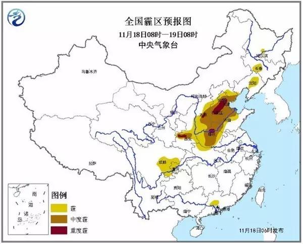
Early warning: severe haze in 7 provinces and cities and strong fog in 5 areas
The Central Meteorological Observatory continued to issue a yellow warning of haze at 6 o’clock this morning. Today, from day to night, there are moderate haze in parts of central and southern Beijing, Tianjin, central and southern Hebei, northwestern Shandong, central and northern Henan, central Shanxi and Guanzhong, Shaanxi, and severe haze in some areas.
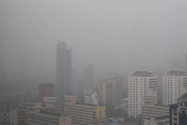
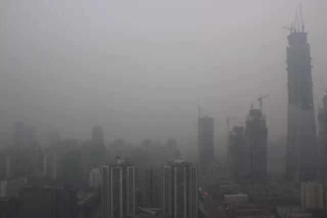
△ Beijing sounded an orange warning of heavy pollution (Photo: vision china)
However, from the morning of the 19th, due to the influence of cold air, the haze in the northern region will gradually weaken or dissipate from north to south.
The Central Meteorological Observatory also issued a foggy yellow warning at 6 o’clock this morning. From this morning to this morning, some areas in the eastern Sichuan Basin, central Jiangxi, southern Hunan, northern Guangdong, northern Zhejiang and other places have strong fog with visibility less than 200 meters, and local areas have extremely strong fog with visibility less than 50 meters.


In the second half of the year, the strongest cold air will come to Huanghuai, North China to welcome the first snow
Since November 10th, heavy snowfall has frequently occurred in northern Xinjiang, and some areas have continuously set a record for the deepest snow in November. It is expected that the snowfall in northern Xinjiang will weaken today, and this round of continuous heavy snowfall will end. However, under the continuous influence of cold air, the temperature will collapse. Take Urumqi as an example. In the next three or four days, the local daily maximum temperature will drop below -10℃.

The Central Meteorological Observatory predicts that there will still be small to medium snow or sleet in eastern Inner Mongolia, the central part of Northeast China, and the Ili Valley in Xinjiang from day to night. Among them, there are heavy snow in parts of northeastern Inner Mongolia, southwestern Heilongjiang and central Jilin. Affected by cold air, the temperature in the northeast of Xinjiang, the eastern part of northwest China, North China, Northeast China, Huanghuai and other places will also drop by 4 to 8 C from today to the 20th, with the local temperature drop in the central and eastern Inner Mongolia and the southern part of Northeast China reaching more than 10 C. The above areas are accompanied by northerly winds of 4~6.

In the next five or six days, the south will be affected by warm and humid air currents, and there will be more rainy weather in Jiangnan, Jianghuai and Jianghan. Among them, there were small to moderate rains in Jiangnan and South China on the 19th, and there was heavy rain in the local area. In addition, there will be a cold air invading China from 20 to 24, and it is likely to be the strongest cold air in the second half of the year. Affected by this, the temperature in most parts of China plummeted, and the first snowfall this winter is expected in North China, Huanghuai and other places.
This winter is particularly cold? Experts predict that this winter may be a "cold winter" in China.
The source of weather changes is often far away. Meteorologists have judged that the winter of 2016/2017 may be a cold winter in China, which is rooted in the melting changes in the Arctic and the "La Nina event" in the equatorial Middle East and Pacific Ocean.

Experts say that after the rapid melting of Arctic sea ice, the albedo (the ratio of reflected flux to incident flux of solar radiation) decreases, and more energy is stored in the ocean. On the one hand, it will accelerate the melting of ice, on the other hand, more energy will be transmitted from the ocean to the atmosphere, changing the air pressure difference between the Arctic region and the mid-latitude region, and bringing cold air from the Arctic region to the mid-latitude region. The effect of the rapid melting of Arctic sea ice on the temperature is the so-called "warm Arctic-cold continent". The decrease of Arctic sea ice is closely related to the winter temperature and precipitation in China, which will lead to the increase of extremely cold temperature in winter and the appearance of cold winter.
On the other hand, the SST in the equatorial Middle East Pacific entered La Nina state in August, and "took over" the previous super El Ni? o event. Monitoring shows that La Nina is expected to last until winter, which has a great impact on the winter temperature in China.

La Nina is a phenomenon that the sea surface temperature in the equatorial, Middle East and Pacific Ocean is unusually cold, which causes abnormal atmospheric circulation and affects the global climate. At present, the entire equatorial Middle East Pacific is in La Nina state, and it is expected that a weak to moderate intensity La Nina event will be formed in December. When La Ni? a state or La Ni? a event occurs, it is easy to be cold in winter in China. (Source: CCTV News, China Weather Network, Xinhua News Agency)
关于作者